Cowichan River Fishing Locations
The Cowichan River is located on Vancouver Island and runs from Cowichan Lake, flows through the city of Duncan and dumps into the ocean in Cowichan Bay. This is a island river carries a variety of fish species and twists and turns through some beautiful mid island country.
A big challenge of fishing this river can be finding foot access. There is a lot of private property along the river so finding access points can require some hiking! Look at the CN rail tracks for some areas to walk and explore off of. And hopefully this map below will give you some general ideas on fishing locations and areas.
Cowichan Valley Trail Head
This is the trail head of the Cowichan Valley Trail. This trail extends all the way up to Lake Cowichan and can be accessed on a few sections of the river.
Silverbridge
Below the bridge on the #1 highway
Trestle Run
Pumphouse
Vaux/Jimy Run-B
Cabin Pool
Hot Creek Pool
Cedar Log Pool
Sandy Pool
Bible Camp
Powerline Run
Washout Pools
Stolz Pool Provincial Park
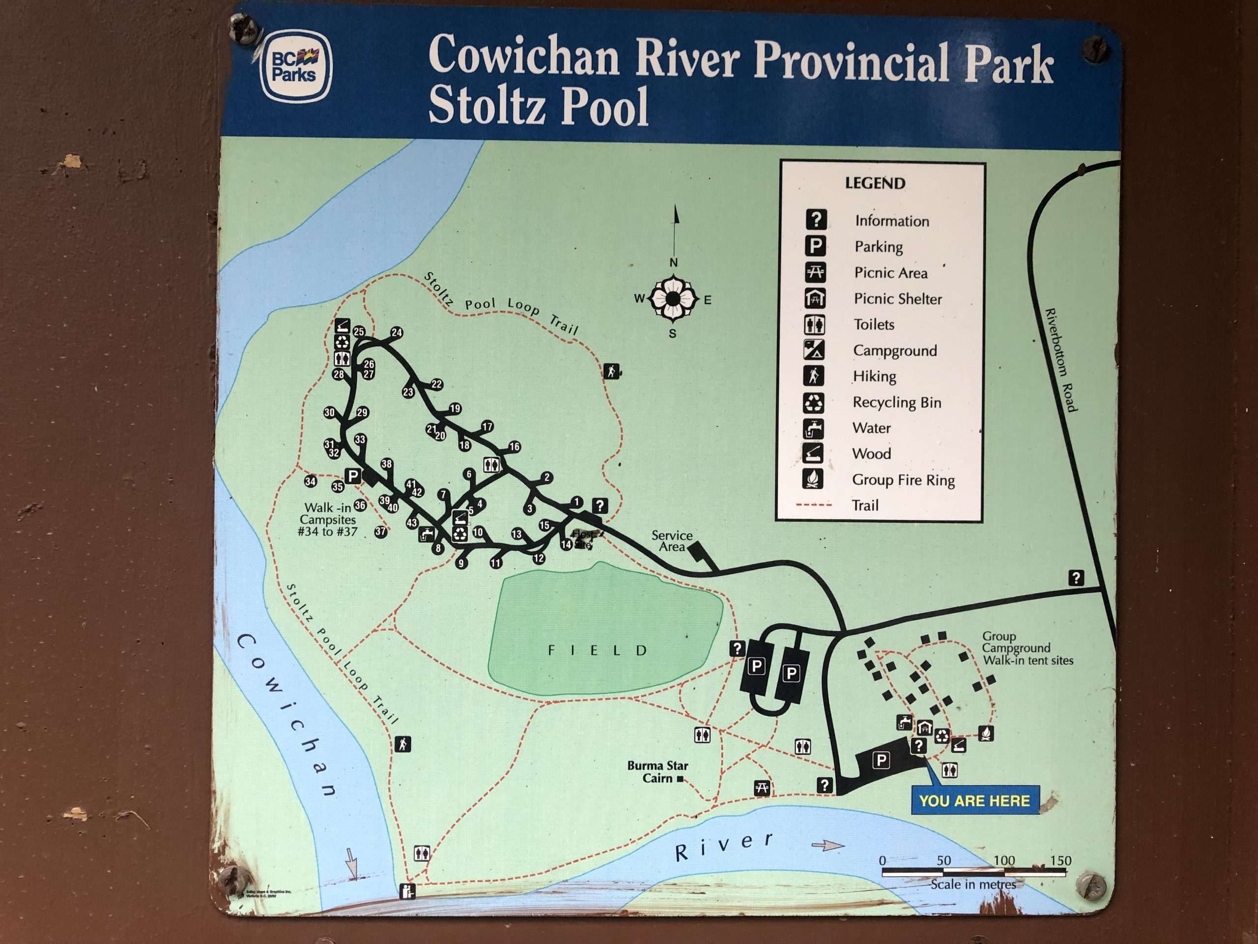
Stoltz Pool Cowichan River Map
Boat Launch
Boat launch beside Stoltz Pool Campground.
Armchair
Marie Canyon
66 Mile Trestle
This marker is often used by DFO for a boundary marker in the Region 1 fishing regulations.
Horseshoe Bend Pools
Skutz Falls
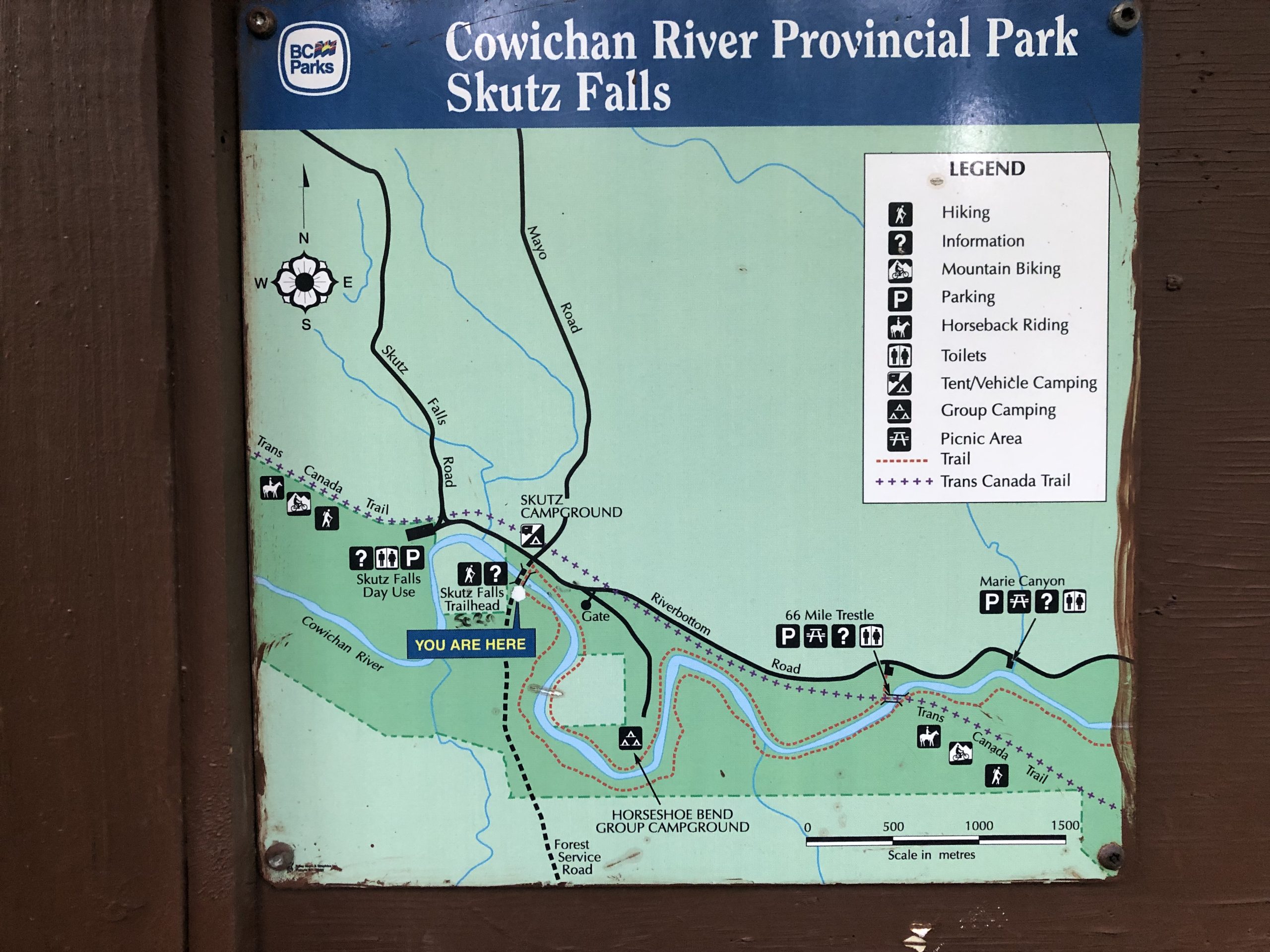
Skutz Falls Cowichan River map
Bear Creek Pool
Hot Spot
Broadway Run
Y Pool
70.2 Mile Bridge
Bridge Pool
Cabin Run
Big Bend Pool
Island Pool
Spring Pool
Rips Run
Otter Pool
Saysell's
Road Bridge-B
E&N Bridge 1
Weir in Lake Cowichan
Cowichan River fishing map locations (bottom to top)
- Silverbridge
- Trestle Run
- Pumphouse
- Vaux/Jimy Run-B
- Cabin Pool
- Hot Creek Pool
- Cedar Log Pool
- Sandy Pool
- Bible Camp
- Powerline Run
- Washout Pools
- Stolz Pool Provincial Park
- Armchair
- Marie Canyon
- Horseshoe Bend Pools
- Skutz Falls
- Bear Creek Pool
- Hot Spot
- Broadway Run
- Y Pool
- 70.2 Mile Bridge
- Bridge Pool
- Cabin Run
- Big Bend Pool
- Island Pool
- Spring Pool
- Rips Run
- Otter Pool
- Saysell's
- Road Bridge-B
- E&N Bridge 1
- Weir in Lake Cowichan


Additional Tips


")


")


