How to Use the Hydrograph
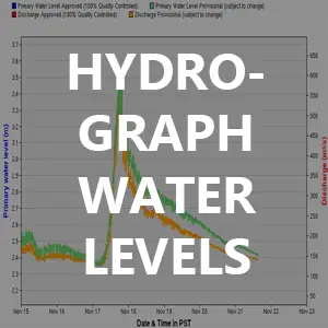
What? A Hydrograph definition can be confusing, so my quickest way to define it is it’s simply a graph that monitors the water flow volume at a specific point. Think of a large ruler jammed into a specific point in/on a river, and as the river water levels move up and down on that ruler, visually you can see the water levels changing in respect to the ruler lines. The online hydrographs provide that same info but on a nice day-by-day format and visual graphs (and much more).
Why? The hydrographs are an incredibly important and helpful piece of information for fisherman. If the body of water your fishing has a posted hydrograph online, that information will give you a glimpse at what the river looks like. And as you get to understand these numbers in relation to the river/body of water you’re fishing, this will become a huge preparation piece in knowing what type of conditions you’ll be facing.
Example Scenario (also see example graph): In an attempt to better articulate the importance of this information here an example. Lets say RIVER A has an average height of 1.7 meters. That means whenever we review the Hydrograph of RIVER A the line graph will usually be around that 1.7 meter number, when there is a lot of rain or melting snow we might see line graph move up to 3 meters, and when its hot and dry with little rain perhaps we might see that river line dive to 1 meter or lower. See graph example below for this scenario.

Before going fishing on RIVER A it’s important to know the current water level in respect to that 1.7 meter number. If the river is around the 3 meter mark, we’ll know the water is high, fast and likely has low water clarity. If the water level is around the 1 meter number, we’ll know the water is low, slower and likely has a high water clarity. Knowing the river levels and conditions will impact what fishing tackle and strategy should be used. For additional information on how to match tackle with water conditions, see Tip: River Conditions vs. Presentation.
Important Reminder: these readings are at one single point on the river, there can be multiple readings on one single river so look for those readers in relation to where you’ll be fishing.
Helpful online resources and links below
Real-Time Hydrometric Reports Map by Canadian Provinces
Alberta: http://wateroffice.ec.gc.ca/google_map/google_map_e.html?searchBy=p&province=AB&doSearch=Go
British Columbia: http://wateroffice.ec.gc.ca/google_map/google_map_e.html?searchBy=p&province=BC&doSearch=Go
New Brunswick: http://wateroffice.ec.gc.ca/google_map/google_map_e.html?searchBy=p&province=NB&doSearch=Go
Newfoundland and Labrador: http://wateroffice.ec.gc.ca/google_map/google_map_e.html?searchBy=p&province=NL&doSearch=Go
Nova Scotia: http://wateroffice.ec.gc.ca/google_map/google_map_e.html?searchBy=p&province=NS&doSearch=Go
Nunavut: http://wateroffice.ec.gc.ca/google_map/google_map_e.html?searchBy=p&province=NU&doSearch=Go
Ontario: http://wateroffice.ec.gc.ca/google_map/google_map_e.html?searchBy=p&province=ON&doSearch=Go
Prince Edward Island: http://wateroffice.ec.gc.ca/google_map/google_map_e.html?searchBy=p&province=PE&doSearch=Go
Quebec: http://wateroffice.ec.gc.ca/google_map/google_map_e.html?searchBy=p&province=QC&doSearch=Go
Saskatechewan: http://wateroffice.ec.gc.ca/google_map/google_map_e.html?searchBy=p&province=SK&doSearch=Go
Yukon: http://wateroffice.ec.gc.ca/google_map/google_map_e.html?searchBy=p&province=YT&doSearch=Go
Water Resources of the United States: http://www.usgs.gov/water/
Current Conditions for Washington: http://waterdata.usgs.gov/wa/nwis/current/?type=flow&group_key=county_cd
Current Conditions for Oregon: http://waterdata.usgs.gov/or/nwis/current?type=flow
National Oceanic and Atmospheric Administration (NOAA) Tide Predictions: http://tidesandcurrents.noaa.gov/tide_predictions.html?gid=259
Additional Tips
