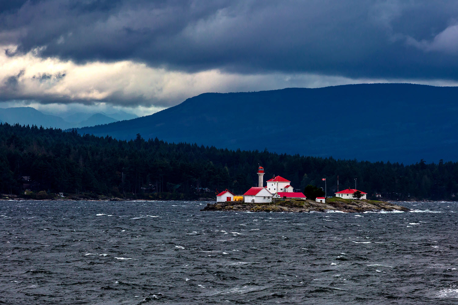
Gulf Islands BC Fishing Locations
The Gulf Islands are located between Vancouver Island and the mainland of BC. These are all found within the Strait of Georgia. These Gulf Islands provide fishing opportunities all year round. Within these islands there are many fishing areas that are given specific names that may or may not link to the geography. For example, "Thrasher Rock" is a popular Salmon area that has no specific rock named Thrasher but is simply a general area just southeast of Gabriola Island. This tip provides some context for these popular fishing names and spots. There are endless places to explore around these islands, this is just a primer.
Please note: these coordinates are down to the minute precision and do not include seconds. How to read GPS coordinates click here.
Active Pass
Off SE corner of Galiano Island, near Ferry route between Galiano & Mayne Island.
Amelia Island
Coordinates: 49°18'00.0"N 124°9'00.0"W
Arbutus Point
Coordinates: 48°49'00.0"N 123°35'00.0"W
Bird Rock
Coordinates: 48°56'00.0"N 123°43'00.0"W
Bold Bluff Point
Near Sansum Narrows just SE of location, closer to Salt Spring Island.
Crofton
Coordinates: 48°52'00.0"N 123°39'00.0"W
Enterprise Reef
Coordinates: 48°51'00.0"N 123°21'00.0"W
Flat Top Islands
Islands just off SE point of Gabriola island, near Thrasher but closer to Gabriola.
Grave Point
Coordinates: 48°51'00.0"N 123°35'00.0"W
Helen Point
Coordinates: 48°51'00.0"N 123°21'00.0"W
Hospital Point
Coordinates: 48°56'00.0"N 123°43'00.0"W
Hospital Rock
Coordinates: 48°56'00.0"N 123°43'00.0"W
Ladysmith Harbour
Just north off Ladysmith.
Mary Anne Point
Coordinates: 48°52'00.0"N 123°19'00.0"W
Miners Bay
Coordinates: 48°51'00.0"N 123°18'00.0"W
Northumberland Channel
Coordinates: 49°09'00.0"N 123°51'00.0"W
Porlier Pass ("the gap")
Pass between Valdes Island & Galiano Island also known as "the gap". This is a very popular fishing area in the Gulf Islands.
Sansum Narrows
Narrows between Salt Spring Island & Vancouver Island (park SE of Maple Bay).
Satellite Channel
Coordinates: 48°43'00.0"N 123°26'00.0"W
Sherard Point
Coordinates: 48°52'00.0"N 123°37'00.0"W
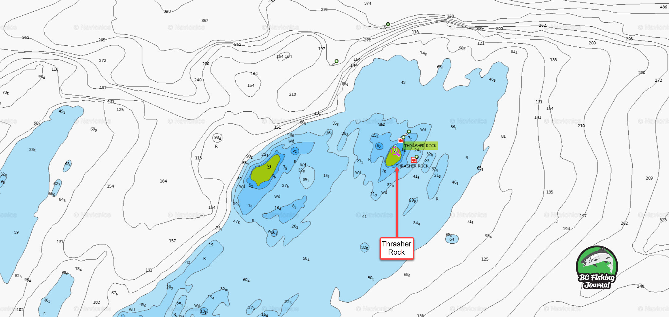
Thrasher Rock
Off SE point of Gabriola Island. This is a very popular location for Winter Chinook and yearly resident Salmon.
Village Bay
Coordinates: 48°51'00.0"N 123°19'00.0"W
Yellow Point
Coordinates: 49°02'00.0"N 123°45'00.0"W
Ballenas Channel
Coordinates: 49°20'00.0"N 124°10'00.0"W
Ballenas Islands
Coordinates: 49°21'00.0"N 124°09'00.0"W
Clarke Rock
Coordinates: 49°13'00.0"N 123°56'00.0"W
Cottam Reef
Coordinates: 49°19'00.0"N 124°11'00.0"W
Departure Bay
Coordinates: 49°12'00.0"N 123°58'00.0"W
Dorcas Point / Rock
Coordinates: 49°19'00.0"N 124°11'00.0"W
Douglas Island
Coordinates: 49°19'00.0"N 124°09'00.0"W
Edgell Banks
Coordinates: 49°16'00.0"N 124°03'00.0"W
Entrance Island
Coordinates: 49°13'00.0"N 123°48'00.0"W
Entrance Island with Gabriola Island in background
Grey Rock
Coordinates: 49°17'00.0"N 124°04'00.0"W
Horswell Bluff
Coordinates: 49°13'00.0"N 123°56'00.0"W
Hudson Rocks
Coordinates: 49°13'00.0"N 123°55'00.0"W
The Fingers
"The Fingers" (Five Finger Island) is a popular hot spot on the salmon highway just off Nanaimo.
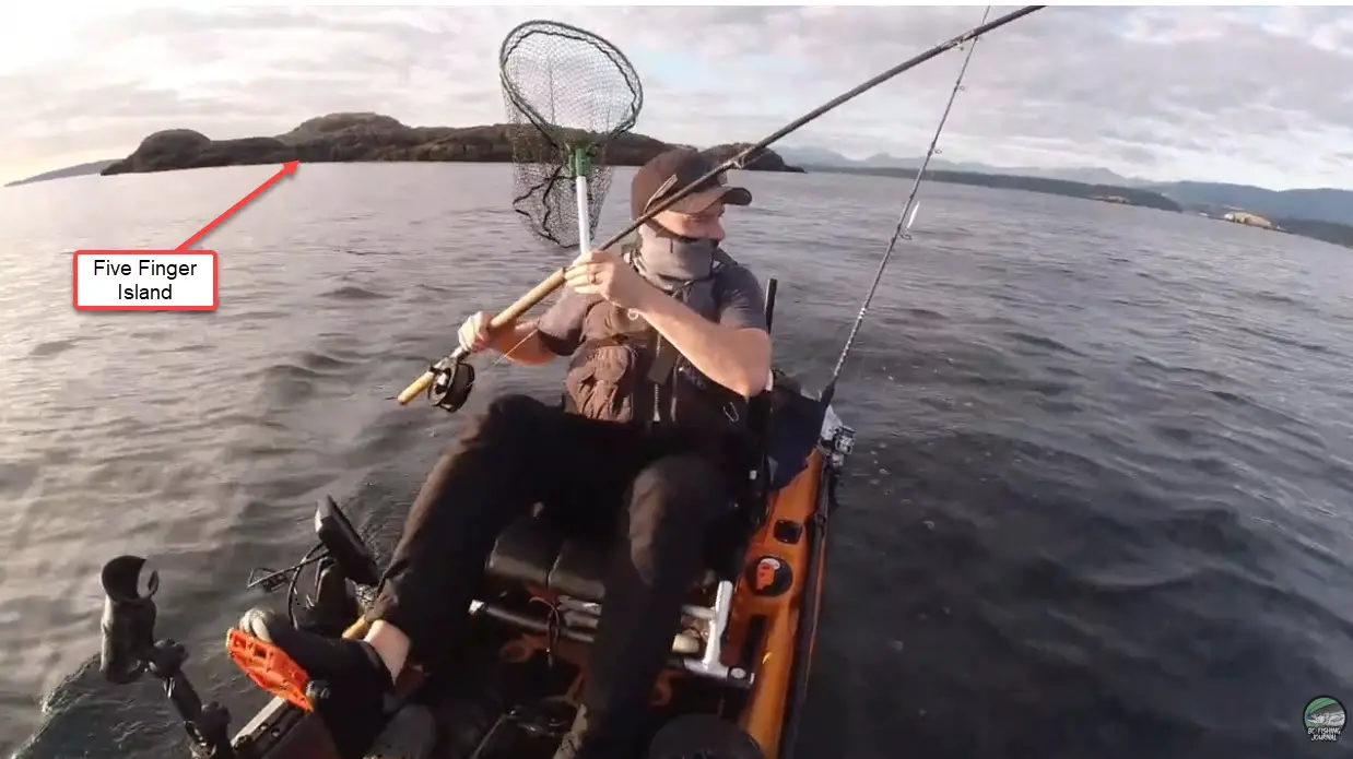
The Fingers island
Nanaimo Harbour
Coordinates: 49°10'00.0"N 123°54'00.0"W
Neck Point
Coordinates: 49°14'00.0"N 123°58'00.0"W
Newcastle Island
Coordinates: 49°11'00.0"N 123°56'00.0"W
Orlebar Point
Coordinates: 49°12'00.0"N 123°49'00.0"W
Pilot Bay
Coordinates: 49°12'00.0"N 123°51'00.0"W
Rainbow Channel
Coordinates: 49°14'00.0"N 123°53'00.0"W
Rudder Rock
Coordinates: 49°17'00.0"N 124°04'00.0"W
Snake Island
Coordinates: 49°13'00.0"N 123°53'00.0"W
Whalebone Point
Coordinates: 49°56'00.0"N 124°48'00.0"W
Winchelsea Islands
Coordinates: 49°18'00.0"N 124°05'00.0"W
Yeo Islands
Coordinates: 49°18'00.0"N 124°08'00.0"W
"The Hump"
"The Hump" is a very popular Salmon fishing location approximately 1-3 miles off the southern tip of Bowen Island. "The hump" refers to a large underwater plateau (running NW to SE). The hump drops off from 480 ft to 700 ft deep (see marine map).
The best time to fish this area for Salmon is mid April to early June. There is a mix of fish heading into Canadian and US river systems.

Bell Buoy (or T10 marker)
A popular location to intercept migrating Salmon. Popular fishing timing would be between August to September.
Coordinates: 49°17'21.3"N 123°15'56.8"W
Hole in the Wall
This is a section of water that stretches just outside of Horseshoe Bay to Sunset Marina area.
Map Instructions
Click the red marker on the map for more information on the fishing location. To zoom in or out, click the + or - buttons in the top left of the map. You can also make the Map a full screen view by clicking the broken square button in the top right.

Resident Feeder Chinooks and Run Times
These are immature Chinook (King) salmon usually around 2-3 years old. They're usually start showing up to the Gulf Islands in the Winter around December and remain in the area until March and April. They are in the area during this time because of the abundance of herring and small bait fish. These fish aren't giants yet and are typically in the 5 lbs to 20 lbs range. That said, these fish are great fighters and super aggressive as they're fattening up to be full adults (spawners) next year.
Migratory Chinooks and Run Times
These are adult Chinook (King) Salmon usually 4+ years old that are making their way back to their birthplaces to spawn. These fish usually start showing up in the Gulf Islands in February and can continue to be found in the area until mid/late October. The overlap (March & April) of the feeder Chinook and migratory Chinook run times can make for some fantastic fishing! However, the majority of the migratory Chinooks show up around late June and early July.
These are the migratory Chinook can range from 10 lbs to 30 lbs (some exceeding 30 lbs). Most of these fish are heading into large rivers within British Columbia, Washington & Oregon (Fraser River, Columbia River, etc.) and then moving into their respective tributaries.


Coho, Pink & Chum Salmon Run Times
There are a number of other Salmon species migrating through the Gulf Islands, here are some of these species and run times.
Coho Salmon begin to show up in August and can continue to be found until December. However, the majority of the Coho will be found between late September to late October.
Pink Salmon show up in early August (most abundant during odd years), these fish come close to shore so can be targeted inshore and off the beach.
Chum Salmon will begin to show up in September but aren't as popular to target as anglers are often targeting Chinook and Coho at this time.
Gulf Islands Areas
Here is additional areas to explore and fish within the Gulf Islands. For space sake these are not all included on the map above. I've included a "Open Map" link which will open the location in Google Maps.
| Location | Coordinates | Google Map URL |
| Active Pass | 48°53'00.0"N 123°18'00.0"W | Open Map |
| Active Point | 48°57'00.0"N 123°40'00.0"W | Open Map |
| Alarm Rock | 48°57'00.0"N 123°41'00.0"W | Open Map |
| Arbutus Point | 48°49'00.0"N 123°35'00.0"W | Open Map |
| Augustus Point | 48°57'00.0"N 123°39'00.0"W | Open Map |
| Bare Point | 48°56'00.0"N 123°42'00.0"W | Open Map |
| Ben Mohr Rock | 48°51'00.0"N 123°23'00.0"W | Open Map |
| Bird Rock | 48°56'00.0"N 123°43'00.0"W | Open Map |
| Boatswain Bank | 48°42'00.0"N 123°33'00.0"W | Open Map |
| Bold Bluff Point | 48°47'00.0"N 123°33'00.0"W | Open Map |
| Boulder Point | 48°23'00.0"N 123°58'00.0"W | Open Map |
| Brant Reef | 49°10'00.0"N 124°40'00.0"W | Open Map |
| Burgoyne Bay | 48°48'00.0"N 123°32'00.0"W | Open Map |
| Burial Islet | 48°46'00.0"N 123°34'00.0"W | Open Map |
| Captain Passage | 48°49'00.0"N 123°24'00.0"W | Open Map |
| Chemainus | 48°55'00.0"N 123°43'00.0"W | Open Map |
| Cherry Point | 48°43'00.0"N 123°33'00.0"W | Open Map |
| Coffin Point | 48°59'00.0"N 123°45'00.0"W | Open Map |
| Collinson Point | 48°52'00.0"N 123°21'00.0"W | Open Map |
| Crofton | 48°52'00.0"N 123°39'00.0"W | Open Map |
| Danger Reefs | 49°03'00.0"N 123°43'00.0"W | Open Map |
| David Cove | 48°51'00.0"N 123°16'00.0"W | Open Map |
| Davis Lagoon | 48°57'00.0"N 123°41'00.0"W | Open Map |
| Dayman Island | 48°58'00.0"N 123°41'00.0"W | Open Map |
| Deer Point | 49°02'00.0"N 123°46'00.0"W | Open Map |
| Dodd Narrows | 49°08'00.0"N 123°49'00.0"W | Open Map |
| Donckele Point | 48°58'00.0"N 123°40'00.0"W | Open Map |
| Duncan | 48°47'00.0"N 123°42'00.0"W | Open Map |
| Dunsmuir Islands | 48°59'00.0"N 123°47'00.0"W | Open Map |
| East Point | 48°47'00.0"N 123°03'00.0"W | Open Map |
| Enterprise Reef | 48°51'00.0"N 123°21'00.0"W | Open Map |
| Flat Top Islands | 49°09'00.0"N 123°41'00.0"W | Open Map |
| Fraser Point | 49°01'00.0"N 123°42'00.0"W | Open Map |
| Fulford Harbour | 48°46'00.0"N 123°26'00.0"W | Open Map |
| Gabriola Island | 49°10'00.0"N 123°48'00.0"W | Open Map |
| Gabriola Passage | 49°08'00.0"N 123°43'00.0"W | Open Map |
| Ganges | 48°51'00.0"N 123°30'00.0"W | Open Map |
| Genoa Bay | 48°46'00.0"N 123°36'00.0"W | Open Map |
| Georgina Point | 48°52'00.0"N 123°17'00.0"W | Open Map |
| Georgina Shoals | 48°52'00.0"N 123°17'00.0"W | Open Map |
| Gossip Island | 48°53'00.0"N 123°19'00.0"W | Open Map |
| Gossip Shoals | 48°53'00.0"N 123°18'00.0"W | Open Map |
| Grave Point | 48°51'00.0"N 123°35'00.0"W | Open Map |
| Helen Point | 48°51'00.0"N 123°21'00.0"W | Open Map |
| Holland Bank | 48°59'00.0"N 123°48'00.0"W | Open Map |
| Hospital Point | 48°56'00.0"N 123°43'00.0"W | Open Map |
| Hospital Rock | 48°56'00.0"N 123°43'00.0"W | Open Map |
| Houstoun Passage | 48°56'00.0"N 123°36'00.0"W | Open Map |
| Hudson Island | 48°58'00.0"N 123°41'00.0"W | Open Map |
| Josling Point | 48°56'00.0"N 123°38'00.0"W | Open Map |
| Location | Coordinates | Google Map URL |
| Kulleet Bay | 49°01'00.0"N 123°46'00.0"W | Open Map |
| Kuper Island | 48°58'00.0"N 123°39'00.0"W | Open Map |
| "Ladder Hole" | 48°52'00.0"N 123°17'00.0"W | Open Map |
| Ladysmith | 48°59'00.0"N 123°49'00.0"W | Open Map |
| Ladysmith Harbour | 48°59'43.4"N 123°48'07.2"W | Open Map |
| Lion Islet | 48°54'00.0"N 123°20'00.0"W | Open Map |
| Maple Bay | 48°49'00.0"N 123°36'00.0"W | Open Map |
| Mary Anne Point | 48°52'00.0"N 123°19'00.0"W | Open Map |
| Maxwell Point | 48°49'00.0"N 123°34'00.0"W | Open Map |
| Miami Islet | 49°02'00.0"N 123°42'00.0"W | Open Map |
| Mill Bay | 48°39'00.0"N 123°33'00.0"W | Open Map |
| Miners Bay | 48°51'00.0"N 123°18'00.0"W | Open Map |
| Monarch Head | 48°46'00.0"N 123°06'00.0"W | Open Map |
| Montague Harbour | 48°53'00.0"N 123°24'00.0"W | Open Map |
| Nanaimo | 49°10'00.0"N 123°56'00.0"W | Open Map |
| Nares Rock | 49°59'00.0"N 123°45'00.0"W | Open Map |
| Narvaez Bay | 48°46'00.0"N 123°06'00.0"W | Open Map |
| North Reef | 48°55'00.0"N 123°38'00.0"W | Open Map |
| Northumberland Channel | 49°09'00.0"N 123°51'00.0"W | Open Map |
| Nose Point | 48°51'00.0"N 123°25'00.0"W | Open Map |
| Octopus Point | 48°48'00.0"N 123°34'00.0"W | Open Map |
| Osborn Bay | 48°52'00.0"N 123°38'00.0"W | Open Map |
| Paddy Mile Stone | 48°49'00.0"N 123°25'00.0"W | Open Map |
| Pilkey Point | 49°01'00.0"N 123°41'00.0"W | Open Map |
| Porlier Pass | 49°01'00.0"N 123°35'00.0"W | Open Map |
| Porlier Pass / Race Point | 49°01'00.0"N 123°35'00.0"W | Open Map |
| Ragged Islets | 49°23'00.0"N 123°27'00.0"W | Open Map |
| Rosenfeld Rock | 48°48'00.0"N 123°02'00.0"W | Open Map |
| Round Island | 49°07'00.0"N 123°48'00.0"W | Open Map |
| Saltspring Island | 48°45'00.0"N 123°29'00.0"W | Open Map |
| Sandstone Rocks | 48°55'00.0"N 123°37'00.0"W | Open Map |
| Sansum Narrows | 48°48'00.0"N 123°34'00.0"W | Open Map |
| Satellite Channel | 48°43'00.0"N 123°26'00.0"W | Open Map |
| Saturna Island | 48°47'00.0"N 123°09'00.0"W | Open Map |
| Scott Island | 48°58'00.0"N 123°42'00.0"W | Open Map |
| Separation Point | 48°44'00.0"N 123°34'00.0"W | Open Map |
| Sharpe Point | 49°21'00.0"N 123°16'00.0"W | Open Map |
| Sherard Point | 48°52'00.0"N 123°37'00.0"W | Open Map |
| Sidney | 48°39'00.0"N 123°24'00.0"W | Open Map |
| Stuart Channel | 49°00'00.0"N 123°42'00.0"W | Open Map |
| Telegraph Harbour | 48°58'00.0"N 123°40'00.0"W | Open Map |
| Tent Island | 48°56'00.0"N 123°38'00.0"W | Open Map |
| Thetis Island | 49°00'00.0"N 123°41'00.0"W | Open Map |
| Thrasher Rock | 49°09'00.0"N 123°39'00.0"W | Open Map |
| Trincomali Channel | 48°58'00.0"N 123°35'00.0"W | Open Map |
| Tumbo Reef | 48°48'00.0"N 123°03'00.0"W | Open Map |
| Valdes Island | 49°05'00.0"N 123°40'00.0"W | Open Map |
| Vesuvius Bay | 48°53'00.0"N 123°34'00.0"W | Open Map |
| Village Bay | 48°51'00.0"N 123°19'00.0"W | Open Map |
| Whaler Bay | 48°53'00.0"N 123°20'00.0"W | Open Map |
| Yellow Point | 49°02'00.0"N 123°45'00.0"W | Open Map |
More Information on the Southern Gulf Islands
If you're looking for further information on the Southern Gulf Islands (e.g. places to explore, things to do, maps, island events, ferries, etc) I'd recommend the Experience the Southern Gulf Islands. This page provides a wealth of tourist information on Galiano, Mayne, Pender, Salt Spring, and Saturna Islands.
Additional Tips


")


")


Other Vancouver Island Fishing Opportunities and Areas
If you want more information on Vancouver Island fishing check out our other tip pages see images/links below. We've got Vancouver Island bank fishing locations to cast from shore as well as Vancouver Island Bass Fishing lakes.
Thanks for checking out BC Fishing Journal. Cheers! Jesse